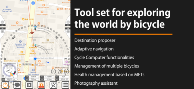
About Bucephalas
【The full version of the Bucephalas series】 This is the full version of the Bucephalas series with the functionality restrictions removed. A FREE version of this app, Bucephalas Tabula rasa , is also available. You can
【The full version of the Bucephalas series】
This is the full version of the Bucephalas series with the functionality restrictions removed.
A FREE version of this app, Bucephalas Tabula rasa , is also available. You can experience the features of the full version in a real ride using Tabula rasa.
【Dialogue by parroting actions】
Bucephalas recognizes your actions and attempts to interact with you by verbally parroting them back to you.
With a navigation app, you would turn right after the app indicates “right turn”. Bucephalus, on the other hand, will say “right turn" after you turn right. In addition, Bucephalus will also parrot back actions such as "stopped," "resume movement," "retreat," and "turned in the direction of the full moon.
【Functions as a cycle computer】
In designing Bucephalas, it is assumed that the bicycle would be the primary means of transportation. Therefore, it also has basic functions as a cycle computer.
• Multiple bicycle management: Bucephalas can register multiple bicycles and record distance traveled and average speed by body.
• Management of bicycle parts by distance traveled: To manage bicycle parts based on the distance traveled, the user can set up a dedicated total distance meter for specific bicycle parts such as tires and brake shoes.
• Elevation and air pressure of the current location
• Altitude gained, maximum altitude gained, and cumulative altitude gained starting from the coordinates of the app's startup
• Voice-guided navigation to the destination
• 3D sound (stereophonic sound) provides direction to the destination.
【Suggestion of destinations on two spatial scales】
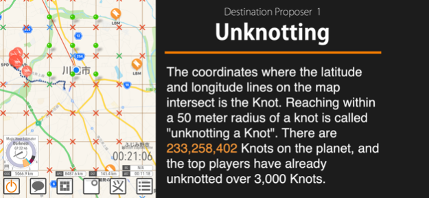
(1) Global Journey = Unknotting Mode
The intersection of a grid of latitude and longitude lines drawn every 1/60th of a degree is called a knot. There are 233,258,402 knots on the entire globe. The objective of Unknotting mode is to reach a circle with a radius of 50 meters centered on the knot.
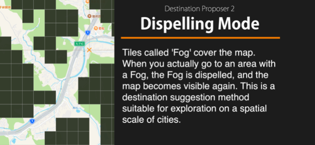
(2) City-Scale Travel = Dispelling Mode
Scaling down the grid of Unknotting to 1/60, the objective is to explore a city from corner to corner. For those who wish to explore the city in even more detail, a movement logging function called Rectangular footprint is provided.
【Destination suggestion method that does not assume a spatial scale】
Mirages are a series of randomly generated coordinates. A Mirage initially appears at a distance of about 1 km from your location, but disappear when you attempt to approach within 25 meters, and then move to another location about 1 km away. The Mirage's coordinates are randomly generated, so there is no way to predict where it will lead you.
You can switch between two mirages (Fata Morgana and Ignis fatuus) (e.g., use one as main and the other as sub).
【As a photography assistant】
Bucephalas is equipped with a Magic Hour estimator to assist with photography while traveling.
Magic Hour is the time of day when the sun is at an altitude close to the horizon and is known to produce impressive lighting conditions.
• The start time of the magic hour (blue hour and golden hour) at the current location
• Moon and sun direction from the current location
• Start time of nautical and astronomical twilight
• Calculation of the direction of the sun and moon at a specific coordinate, date, and time
【Warning】
Many of the destinations suggested by the application include those that are difficult or dangerous to approach. Please do not approach those knots by force.
This app uses GPS even in the background; continuous use of GPS will rapidly drain the iPhone battery.
【Integration with the Health App】
This app will attempt to obtain your body mass data from Health app. The data obtained are used to convert the amount of your physical activity represented in METs•Hour into calories burned. Also, physical activity recorded in this app can be exported to Health app.
Apr 25, 2024
Version 11.0.2
[1: Excluded visibility] Visibility has been excluded from the weather information reported.
[2: Other tweaks] Other tweaks
•Fixed a bug regarding the name of the setting moon.
•Introduced a mechanism to monitor velocity anomalies.
Previous Versions
Here you can find the changelog of Bucephalas since it was posted on our website on 2016-10-03 11:03:23.
The latest version is 11.0.2 and it was updated on 2024-04-27 13:04:43. See below the changes in each version.
Bucephalas version 11.0.2
Updated At: 2024-04-25
Changes: Apr 25, 2024
Version 11.0.2
[1: Excluded visibility] Visibility has been excluded from the weather information reported.
[2: Other tweaks] Other tweaks
•Fixed a bug regarding the name of the setting moon.
•Introduced a mechanism to monitor velocity anomalies.
Bucephalas version 11.0.1
Updated At: 2024-04-14
Changes: Apr 14, 2024
Version 11.0.1
【1: Pressing and holding the GPS On/Off button】
When the GPS is turned off, pressing and holding the GPS On/Off button will temporarily turn on the GPS and display the current location. If this is not possible, the last recorded location will be displayed. (Previously, only the latter process was used)
【2:Course distance】
Course distance can now be displayed.
【3:Coordinates bookmark】
You can now choose to automatically enter a category name as the name of a new bookmark when it is generated. The response when sorting bookmarks has also been adjusted.
【4: Settings related to heading estimation】
The settings for heading estimation and map matching have been integrated into the calibration menu that appears when the tracking mode button is long-pressed.
Bucephalas version 11.0.0
Updated At: 2024-03-25
Changes: Mar 25, 2024
Version 11.0.0
1) Added the ability to draw a route. Unlike routes that change dynamically during navigation, fixed, pre-edited routes can be displayed on the map. Such a route is called a course.
(2) The system now recognizes the state of travel by vehicle even when the means of transportation is set to walk/run.
(a) Vehicle: An option when the main mode of transportation is non-human-powered, such as a private car or public transportation. Walking/running is recognized depending on the situation, but if the vehicle travels at a typical jogging speed (6.4 km/h) or faster, it is recognized as traveling by vehicle. Travel by bicycle is not recognized.
(b) Walking/running: Recognition of walking/running is preferred, but movement by vehicle is recognized depending on the situation. Movement by bicycle is not recognized. Actual speed of movement is possible.
(c) Bicycle (no change): Option for travel primarily by bicycle. Recognizes movement on foot/running and movement by vehicle, depending on the situation. Option to suppress recognition of walking/running is available.
(3) [Exercise Time] The physical activity (METs-Hour and kilocalories) displayed in the Session Summary tab is the total amount of activity with a load of 3 METs or more. Starting with this version, the time (Exercise Time) in which that totalization was performed is displayed.
(4) Changed the flick operation to the long press.
The activation method for the following functions has been changed from flicking to long pressing.
(a) To display the current location that was displayed immediately before on the map, long-press the location on/off button.
(b) To immediately iterate route guidance, long-press the route guidance button.
(c) To manually correct the heading direction, long-press the Tracking Mode button.
(5) Heading Estimation Algorithm
Algorithm to compensate for electronic compass and GPS errors has been updated.
(6) Bug fixes
(a) A bug that caused longer travel time than actual to be recorded has been corrected.
(b) Fixed a bug in the path deviation judgment algorithm.
Bucephalas version 10.8.0
Updated At: 2023-12-21
Changes: Dec 21, 2023
Version 10.8.0
(1) Added walking/running aids. It announces changes in speed in real time so that you can constantly check your moving pace. This function is activated when the transport type is set to "Walk/Run (speed report)".
(2) Calorie consumption data can now be sent to the Health App.
(3) Improved algorithm for automatic control of map center. In the tracking mode synchronized with heading, the map center (current location) is shifted to the bottom of the screen so that the direction of travel can be widely displayed. However, if the path indicated during navigation is backward, the map center is adjusted so that the rearward direction can be widely displayed.
(4) The route deviation judgment function has been improved. It is now able to make more reasonable judgments than before.
(5) Fixed a bug that causes the same utterance to be repeated meaninglessly.
Bucephalas version 10.7.3
Updated At: 2023-11-17
Changes: Nov 17, 2023
Version 10.7.3
(1) Fixed a bug that caused unnatural temperature and UV index reporting messages.
(2) Modified the Blackout screen to a simpler one.
(3) Visibility is included in the weather report.
Bucephalas version 10.7.2
Updated At: 2023-11-12
Changes: Nov 12, 2023
Version 10.7.2
Changed the Dispelling Mode spec. The Singular-Fog detection sound is new.
Bucephalas version 10.7.1
Updated At: 2023-10-24
Changes: Oct 24, 2023
Version 10.7.1
(1) Weather information may be mentioned (iOS 16.4 or later).
(2) A button to invoke the Effective Circle Radius Extension UI has been placed on the map view.
Bucephalas version 10.6.3
Updated At: 2023-09-29
Changes: Sep 29, 2023
Version 10.6.3
(1) Widget is now compatible with iOS17.
(2) Fixed a bug where lines representing knots were not displayed when OpenStreetMap or OpenCycleMap is selected.
Bucephalas version 10.6.1
Updated At: 2023-09-16
Changes: Sep 16, 2023
Version 10.6.1
(1) Fixed a bug related to Japanese conversion.
(2) Fixed a bug in which the session was interrupted when the launch coordinates were re-measured.
(3) Fixed a bug that caused a crash while editing bicycle information.
Bucephalas version 10.6.0
Updated At: 2023-09-03
Changes: Sep 3, 2023
Version 10.6.0
(1) The application cannot be operated while riding a bicycle.
(2) As the neighborhood of the mirage is reached and the level increases, bonus points are added to the effective circle radius extension score.
(3) The function to automatically turn off location services at past startup coordinates or base coordinates will not be activated near (within 1 km) the current startup coordinates or base coordinates.It will also not be triggered if the user has not been in the vicinity of the past coordinates for more than 30 minutes.
(4) Adjustment of the activity state recognition algorithm: Recognition of stop states will be performed at a higher frequency than before.
(5) Elevation difference between the destination and current location may be spoken.
(6) When navigation to a destination is being carried out, the destination and the end point of the route may not coincide (e.g., the road to the destination does not exist). The response in such cases has been adjusted to be more natural.
(7) Recommends checking bicycle tire pressure every 7 days for each registered bike.